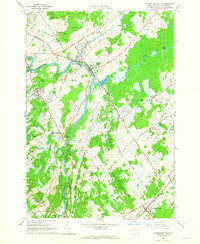
1963 Map of Rensselaer Falls
USGS Topo · Published 1965About this map
The Oswegatchie River defines the landscape of this St. Lawrence County region, winding northward through the heart of De Kalb and Oswegatchie. The village of Rensselaer Falls sits at a critical bend where the river meets Indian Creek and Lower Lake, serving as a focal point for the surrounding rural townships. The southern portion of the map is dominated by the industrial and transport activity at De Kalb Junction, where the New York Central railroad corridor facilitates movement across the countryside.
Find a feature on this map
44 named features on this map. Tap any name to fly to it.
Don’t see what you’re looking for? This feature index may not catch every label — zoom into the map to look around manually.
Map Details
Editions of this 1963 Rensselaer Falls Map
This is the sole edition of this map. No revisions or reprints were ever made.
Other maps of this area

1904 · Ogdensburg
USGS Topo · 1:62,500

1905 · Ogdensburg
USGS Topo · 1:62,500

1910 · Canton
USGS Topo · 1:62,500

1911 · Canton
USGS Topo · 1:62,500

1915 · Gouverneur
USGS Topo · 1:62,500

1915 · Russell
USGS Topo · 1:62,500

1918 · Russell
USGS Topo · 1:62,500

1937 · Gouverneur
USGS Topo · 1:62,500

1943 · Ogdensburg East
USGS Topo · 1:31,680

1943 · Rensselaer Falls
USGS Topo · 1:31,680