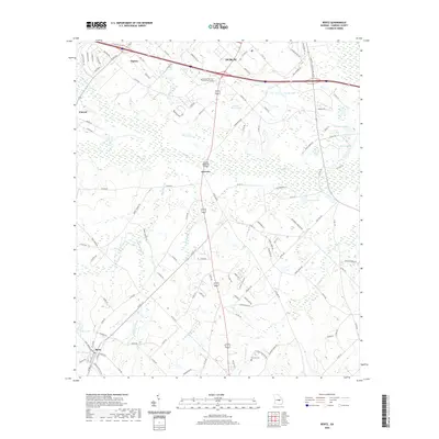
2020 Map of Rentz
USGS Topo · Published 2020About this map
The southern outskirts of Dublin and the rural agricultural landscapes of Laurens County define this modern topographic survey. The area transitions from the educational hub of Oconee Fall Line Technical College near the northern edge down through a network of creeks and small settlements. Local history is anchored by the town of Rentz in the southwest corner and smaller named locales like Garretta, Harlow, and Vincent. The terrain is deeply carved by drainage systems including Turkey Creek, Bluewater Creek, and the headwaters of Reedy Springs Branch. Family-named landmarks and historical burial grounds such as Pearson Cemetery provide valuable geographic markers for genealogists tracing property lines and family origins in this part of Georgia. A series of small reservoirs, including Lamar Smith Lake, Greene Lake, and Bailey Lake, dot the low-lying areas between the county's rolling hills.
Find a feature on this map
115 named features on this map. Tap any name to fly to it.
Don’t see what you’re looking for? This feature index may not catch every label — zoom into the map to look around manually.
Map Details
Editions of this 2020 Rentz Map
This is the sole edition of this map. No revisions or reprints were ever made.
Other maps of this area

1957 · Macon
USGS Topo · 1:250,000

1958 · Macon
USGS Topo · 1:250,000

1964 · Macon
USGS Topo · 1:250,000

1973 · Cadwell
USGS Topo · 1:24,000

1974 · Lowery
USGS Topo · 1:24,000

1974 · Five Points
USGS Topo · 1:24,000

1974 · Rentz
USGS Topo · 1:24,000

1974 · Dudley
USGS Topo · 1:24,000

1974 · East Dublin
USGS Topo · 1:24,000
1974 · Dexter
USGS Topo · 1:24,000