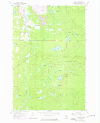
1955 Map of Republic SW
USGS Topo · Published 1977About this map
The Michigamme River carves through the heart of the Michigamme State Forest, anchoring a landscape defined by an intricate network of waterways and early industrial activity. Near the northern boundary, the presence of pits and a substantial Tailings Pond indicates the intensive mineral extraction that shaped the Marquette Range during the mid-20th century. The terrain is densely packed with named water bodies, including the centrally located Loon Lake, Big Lick Lake, and the winding Chain of Lakes.
Find a feature on this map
37 named features on this map. Tap any name to fly to it.
Don’t see what you’re looking for? This feature index may not catch every label — zoom into the map to look around manually.
Map Details
Editions of this 1955 Republic SW Map
2 editions found

Other maps of this area

1899 · Sagola
USGS Topo · 1:62,500

1899 · Witbeck
USGS Topo · 1:62,500

1955 · Witch Lake
USGS Topo · 1:24,000

1955 · Ralph NW
USGS Topo · 1:24,000

1955 · Ralph NE
USGS Topo · 1:24,000

1955 · Witch Lake NE
USGS Topo · 1:24,000

1955 · Greenwood
USGS Topo · 1:24,000

1955 · Republic
USGS Topo · 1:62,500

1955 · Republic
USGS Topo · 1:24,000

1955 · Witch Lake
USGS Topo · 1:62,500