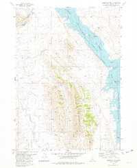
1981 Map of Reservoir Mtn
USGS Topo · Published 1982About this map
Reservoir Mountain dominates the center of this landscape, its steep slopes descending eastward into the Blackfoot River Reservoir. This high-altitude basin in Caribou County shows a shoreline shaped by the constriction of The Narrows, where the water transitions between broader reaches. Human activity is largely limited to recreation and resource extraction, evidenced by Hopkins Landing on the southeastern shore and various prospects and a Gravel Pit scattered across the uplands.
Find a feature on this map
21 named features on this map. Tap any name to fly to it.
Don’t see what you’re looking for? This feature index may not catch every label — zoom into the map to look around manually.
Map Details
Editions of this 1981 Reservoir Mtn Map
This is the sole edition of this map. No revisions or reprints were ever made.
Other maps of this area

1914 · Henry
USGS Topo · 1:48,000

1916 · Henry
USGS Topo · 1:62,500

1917 · Portneuf
USGS Topo · 1:62,500

1917 · Cranes Flat
USGS Topo · 1:62,500

1918 · Paradise Valley
USGS Topo · 1:62,500

1955 · Driggs
USGS Topo · 1:250,000

1955 · Preston
USGS Topo · 1:250,000

1958 · Driggs
USGS Topo · 1:250,000

1958 · Preston
USGS Topo · 1:250,000

1962 · Driggs
USGS Topo · 1:250,000