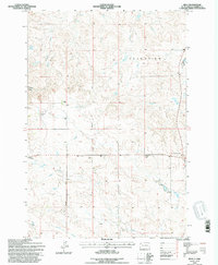
1993 Map of Reva
USGS Topo · Published 1996About this map
Reva sits at a historic crossroads in Harding County, where local life centered around the Reva Sch and a network of remote family operations. The map documents a rugged landscape defined by the Battle of Slim Buttes landmark and the elevated terrain of Grandview. Drainage patterns from McPherson Creek and Fisher Creek carve through the territory, punctuated by isolated sites such as the Besler Ranch and G Lermeney Ranch.
Find a feature on this map
18 named features on this map. Tap any name to fly to it.
Don’t see what you’re looking for? This feature index may not catch every label — zoom into the map to look around manually.
Map Details
Editions of this 1993 Reva Map
This is the sole edition of this map. No revisions or reprints were ever made.
Other maps of this area

1935 · Reva
USGS Topo · 1:125,000

1935 · Hoover
USGS Topo · 1:125,000

1954 · Lemmon
USGS Topo · 1:250,000

1957 · Lemmon
USGS Topo · 1:250,000

1968 · J B Hill
USGS Topo · 1:24,000

1968 · Reva
USGS Topo · 1:24,000

1968 · Flat Top Butte
USGS Topo · 1:24,000

1969 · Battleship Rock
USGS Topo · 1:24,000

1969 · Reva NW
USGS Topo · 1:24,000

1969 · Reva NE
USGS Topo · 1:24,000