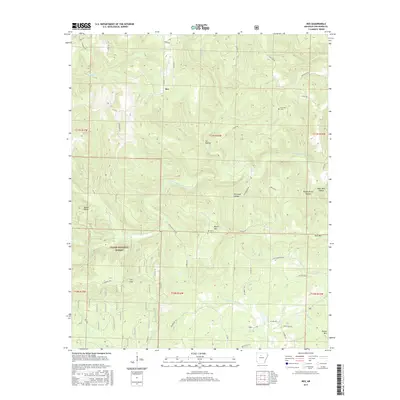
2017 Map of Rex
USGS Topo · Published 2017About this map
Rex sits amidst the drainage divides of the Ozark National Forest, where the topography is defined by the winding paths of the South Fork Little Red River and its numerous tributaries. This 2017 survey details a landscape where traditional Ozark hollows like Sis Hollow, Pigeon Roost Hollow, and Bear Hole Hollow separate prominent peaks such as Black Mtn and Gulf Mtn. The map reveals a transition from the forest's interior to the surrounding highland communities through a network of secondary roads and forest tracks.
Find a feature on this map
55 named features on this map. Tap any name to fly to it.
Don’t see what you’re looking for? This feature index may not catch every label — zoom into the map to look around manually.
Map Details
Editions of this 2017 Rex Map
This is the sole edition of this map. No revisions or reprints were ever made.
Other maps of this area

1879 · Washington
USGS Topo · 1:62,500

1887 · Smyrna
USGS Topo · 1:62,500

1889 · Marshall #3
USGS Topo · 1:62,500

1892 · Marshall
USGS Topo · 1:125,000

1892 · Morrillton
USGS Topo · 1:125,000

1894 · Morrillton
USGS Topo · 1:125,000

1894 · Marshall
USGS Topo · 1:125,000

1901 · Marshall
USGS Topo · 1:125,000

1940 · Smyrna
USGS Topo · 1:62,500
1943 · Smyrna
USGS Topo · 1:62,500