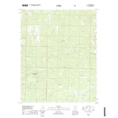
2020 Map of Rex
USGS Topo · Published 2020About this map
The Rex community sits at a high-elevation crossroads within the Ozark National Forest, where the headwaters of several significant drainages originate. The landscape is defined by its dramatic relief, including Gulf Mountain and Black Mountain, which overlook deep-cut drainages like Sis Hollow and Pigeon Roost Hollow. The mapping reveals a remote network of timber and access roads, such as Slick Rock Ford Road and Wilderness Trail, which service the scattered residents of the northern Van Buren County hills. Evidence of long-standing local lineage is preserved in the location of the Low Gap Cemetery and Burke Cemetery, while the varied flow of the South Fork Little Red River and W Fork Point Remove Creek highlights the area's role as a major watershed divide.
Find a feature on this map
55 named features on this map. Tap any name to fly to it.
Don’t see what you’re looking for? This feature index may not catch every label — zoom into the map to look around manually.
Map Details
Editions of this 2020 Rex Map
This is the sole edition of this map. No revisions or reprints were ever made.
Other maps of this area

1879 · Washington
USGS Topo · 1:62,500

1887 · Smyrna
USGS Topo · 1:62,500

1889 · Marshall #3
USGS Topo · 1:62,500

1892 · Marshall
USGS Topo · 1:125,000

1892 · Morrillton
USGS Topo · 1:125,000

1894 · Morrillton
USGS Topo · 1:125,000

1894 · Marshall
USGS Topo · 1:125,000

1901 · Marshall
USGS Topo · 1:125,000

1940 · Smyrna
USGS Topo · 1:62,500
1943 · Smyrna
USGS Topo · 1:62,500