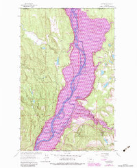
1983 Map of Rexford
USGS Topo · Published 1984About this map
The Tobacco Plains and the winding course of the Kootenai River dominate this borderland landscape just south of the Canadian line. This photorevised 1983 record highlights the expansion of water features and recreational facilities, including the Murray Springs State Fish Hatchery and several shoreline developments like the Tobacco Plains Boat Ramp and Gateway Campground. The settlement of Rexford sits near the confluence with the Tobacco River, while large islands like Kins Island and Whites Island break the river's flow through the valley floor. To the west, the terrain rises into the Kootenai National Forest, where smaller water bodies like Tooley Lake and its associated Tooley Lake Sch provide evidence of earlier rural community structures. The map serves as a vital record of the valley's hydrography and land use before subsequent regional changes.
Find a feature on this map
47 named features on this map. Tap any name to fly to it.
Don’t see what you’re looking for? This feature index may not catch every label — zoom into the map to look around manually.
Map Details
Editions of this 1983 Rexford Map
This is the sole edition of this map. No revisions or reprints were ever made.
Other maps of this area

1957 · Kalispell
USGS Topo · 1:250,000

1960 · Kalispell
USGS Topo · 1:250,000

1961 · Kalispell
USGS Topo · 1:250,000

1963 · Rexford
USGS Topo · 1:24,000

1963 · Eureka North
USGS Topo · 1:24,000

1963 · Eureka South
USGS Topo · 1:24,000

1963 · Red Mountain
USGS Topo · 1:24,000

1963 · Webb Mountain
USGS Topo · 1:24,000
1963 · Beartrap Mountain
USGS Topo · 1:24,000

1979 · Yaak River
USGS Topo · 1:100,000