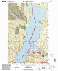
1997 Map of Rexford
USGS Topo · Published 2000About this map
Lake Koocanusa dominates this landscape along the international border, following the flooded valley of the Kootenai River through the heart of the Kootenai National Forest. In the late 1990s, the area reflects a shift toward recreation and conservation, centered around the relocated town of Rexford and the extensive Tobacco Plains to the east. The geography reveals a blend of mountainous terrain and developed water access, with infrastructure like the Mariners Haven Boat Dock and Rexford Bench serving the reservoir.
Find a feature on this map
36 named features on this map. Tap any name to fly to it.
Don’t see what you’re looking for? This feature index may not catch every label — zoom into the map to look around manually.
Map Details
Editions of this 1997 Rexford Map
This is the sole edition of this map. No revisions or reprints were ever made.
Other maps of this area

1957 · Kalispell
USGS Topo · 1:250,000

1960 · Kalispell
USGS Topo · 1:250,000

1961 · Kalispell
USGS Topo · 1:250,000

1963 · Rexford
USGS Topo · 1:24,000

1963 · Eureka North
USGS Topo · 1:24,000

1963 · Eureka South
USGS Topo · 1:24,000

1963 · Red Mountain
USGS Topo · 1:24,000

1963 · Webb Mountain
USGS Topo · 1:24,000
1963 · Beartrap Mountain
USGS Topo · 1:24,000

1979 · Yaak River
USGS Topo · 1:100,000