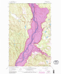
1963 Map of Rexford
USGS Topo · Published 1984About this map
The town of Rexford sits at the confluence of the Tobacco River and the expansive Lake Kootenai, a landscape defined by the shifting waters of the Kootenai River along the international border. This 1963 survey, revised in the early 1980s, documents a region of high-country lakes and timberland within the Kootenai National Forest. Notable landmarks such as the Murray Springs State Fish Hatchery and Tobacco Plains Boat Ramp reflect the area's importance for local resource management and recreation.
Find a feature on this map
40 named features on this map. Tap any name to fly to it.
Don’t see what you’re looking for? This feature index may not catch every label — zoom into the map to look around manually.
Map Details
Editions of this 1963 Rexford Map
3 editions found
Other maps of this area

1957 · Kalispell
USGS Topo · 1:250,000

1960 · Kalispell
USGS Topo · 1:250,000

1961 · Kalispell
USGS Topo · 1:250,000

1963 · Rexford
USGS Topo · 1:24,000

1963 · Eureka North
USGS Topo · 1:24,000

1963 · Eureka South
USGS Topo · 1:24,000

1963 · Red Mountain
USGS Topo · 1:24,000

1963 · Webb Mountain
USGS Topo · 1:24,000
1963 · Beartrap Mountain
USGS Topo · 1:24,000

1979 · Yaak River
USGS Topo · 1:100,000