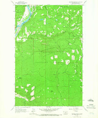
1963 Map of Beartrap Mountain
USGS Topo · Published 1966About this map
The town of Rexford sits at the northwestern edge of this 1963 survey, positioned where the Great Northern railroad tracks parallel the curves of the Kootenai River. This section of Lincoln County is dominated by the steep rises of the Kootenai National Forest, featuring the prominent peaks of Beartrap Mountain and Helmer Mountain. The landscape is a network of drainage basins and high-elevation water bodies like Rock Lake, Phills Lake, and Mud Lake, connected by numerous seasonal draws and creeks.
Find a feature on this map
26 named features on this map. Tap any name to fly to it.
Don’t see what you’re looking for? This feature index may not catch every label — zoom into the map to look around manually.
Map Details
Editions of this 1963 Beartrap Mountain Map
2 editions found
Other maps of this area

1957 · Kalispell
USGS Topo · 1:250,000

1960 · Kalispell
USGS Topo · 1:250,000

1961 · Kalispell
USGS Topo · 1:250,000

1963 · Rexford
USGS Topo · 1:24,000

1963 · Eureka North
USGS Topo · 1:24,000

1963 · Mc Guire Mountain
USGS Topo · 1:24,000

1963 · Eureka South
USGS Topo · 1:24,000

1963 · Red Mountain
USGS Topo · 1:24,000

1963 · Webb Mountain
USGS Topo · 1:24,000
1963 · Pinkham Mountain
USGS Topo · 1:24,000