
1963 Map of Webb Mountain
USGS Topo · Published 1966About this map
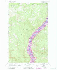
Kootenai National Forest blankets the steep topography of this 1963 survey, where the Kootenai River carves a deep valley through the mountains. This corridor serves as a vital transportation artery, containing both the Great Northern railroad line and a main roadway following the river's eastern bank. Higher elevations are marked by the Webb Mountain Lookout and the prominent summit of Scalp Mountain.
Find a feature on this map
17 named features on this map. Tap any name to fly to it.
Don’t see what you’re looking for? This feature index may not catch every label — zoom into the map to look around manually.
Map Details
Editions of this 1963 Webb Mountain Map
2 editions found
Other maps of this area

1957 · Kalispell
USGS Topo · 1:250,000

1960 · Kalispell
USGS Topo · 1:250,000

1961 · Kalispell
USGS Topo · 1:250,000

1963 · Rexford
USGS Topo · 1:24,000

1963 · Robinson Mountain
USGS Topo · 1:24,000

1963 · Mc Guire Mountain
USGS Topo · 1:24,000

1963 · Red Mountain
USGS Topo · 1:24,000

1963 · Boulder Lakes
USGS Topo · 1:24,000
1963 · Inch Mountain
USGS Topo · 1:24,000
1963 · Beartrap Mountain
USGS Topo · 1:24,000