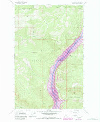
1963 Map of Webb Mountain
USGS Topo · Published 1984About this map
Lake Koocanusa dominates the central valley of this 1963 survey, reflecting a landscape undergoing significant transformation within the Kootenai National Forest. The map shows the Kootenai River before the full impact of regional water management, with purple revisions from 1982 indicating the pool elevation of the reservoir. High-altitude vantage points like the Webb Mountain Lookout and the summit of Scalp Mountain overlook a network of drainages including Pinkham Creek and Boulder Creek.
Find a feature on this map
19 named features on this map. Tap any name to fly to it.
Don’t see what you’re looking for? This feature index may not catch every label — zoom into the map to look around manually.
Map Details
Editions of this 1963 Webb Mountain Map
2 editions found
Other maps of this area

1957 · Kalispell
USGS Topo · 1:250,000

1960 · Kalispell
USGS Topo · 1:250,000

1961 · Kalispell
USGS Topo · 1:250,000

1963 · Rexford
USGS Topo · 1:24,000

1963 · Robinson Mountain
USGS Topo · 1:24,000

1963 · Mc Guire Mountain
USGS Topo · 1:24,000

1963 · Red Mountain
USGS Topo · 1:24,000

1963 · Webb Mountain
USGS Topo · 1:24,000

1963 · Boulder Lakes
USGS Topo · 1:24,000
1963 · Inch Mountain
USGS Topo · 1:24,000