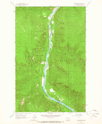
1963 Map of Inch Mountain
USGS Topo · Published 1966About this map
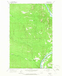
The Kootenai River carves a deep valley through the Kootenai National Forest in this 1963 survey of northwestern Montana. This landscape is defined by the critical transport corridor of the Great Northern railway, which skirts the eastern bank of the river as it winds past Cedar Island and the rock formations of Stonehill. The map captures a moment before modern landscape modifications, showing the intricate drainage patterns of tributaries like Big Creek, McGuire Creek, and the various forks of Parsnip Creek. High above the river valley, the Vortex Lookout Tower stands as a sentinel near Inch Mountain, connected to the lower elevations by a primitive Pack Trail. The presence of these lookout points and wilderness trails reflects the mid-century forest management and fire suppression infrastructure in this corner of Lincoln County.
Find a feature on this map
21 named features on this map. Tap any name to fly to it.
Don’t see what you’re looking for? This feature index may not catch every label — zoom into the map to look around manually.
Map Details
Editions of this 1963 Inch Mountain Map
2 editions found
Other maps of this area

1957 · Kalispell
USGS Topo · 1:250,000

1960 · Kalispell
USGS Topo · 1:250,000

1961 · Kalispell
USGS Topo · 1:250,000

1963 · Mc Guire Mountain
USGS Topo · 1:24,000

1963 · Banfield Mountain
USGS Topo · 1:24,000

1963 · Webb Mountain
USGS Topo · 1:24,000

1963 · Boulder Lakes
USGS Topo · 1:24,000
1963 · Volcour
USGS Topo · 1:24,000
1963 · Beartrap Mountain
USGS Topo · 1:24,000
1963 · Ural
USGS Topo · 1:24,000