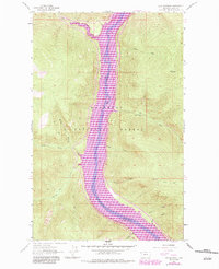
1963 Map of Inch Mountain
USGS Topo · Published 1984About this map
Lake Koocanusa dominates this mountainous landscape within the Kootenai National Forest, reflecting a major environmental shift after the construction of Libby Dam. This specific survey includes purple revisions from the early 1980s, revealing the reservoir's extent over the original path of the Kootenai River. The terrain is marked by steep drainages like Big Creek and McGuire Creek which feed into the valley. Higher elevations are anchored by the Inch Mountain peak and the Warland Lookout Tower, while the valley floor features the Peck Gulch Campground and Cedar Island. For historians, the map captures the transition from a river-centered valley to a reservoir-controlled environment, documented through the Kootenai National Forest boundaries and various named gulches like Peck Gulch and Allen Gulch that became shoreline features.
Find a feature on this map
20 named features on this map. Tap any name to fly to it.
Don’t see what you’re looking for? This feature index may not catch every label — zoom into the map to look around manually.
Map Details
Editions of this 1963 Inch Mountain Map
2 editions found
Other maps of this area

1957 · Kalispell
USGS Topo · 1:250,000

1960 · Kalispell
USGS Topo · 1:250,000

1961 · Kalispell
USGS Topo · 1:250,000

1963 · Mc Guire Mountain
USGS Topo · 1:24,000

1963 · Banfield Mountain
USGS Topo · 1:24,000

1963 · Webb Mountain
USGS Topo · 1:24,000

1963 · Boulder Lakes
USGS Topo · 1:24,000
1963 · Volcour
USGS Topo · 1:24,000
1963 · Inch Mountain
USGS Topo · 1:24,000
1963 · Beartrap Mountain
USGS Topo · 1:24,000