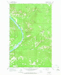
1963 Map of Volcour
USGS Topo · Published 1966About this map
Kootenai River defines the canyon corridor of this northwestern Montana survey, where the Great Northern railroad tracks follow the river's winding path through the Kootenai National Forest. The small settlements of Warland and Volcour occupy narrow benches of flat land between the water and the steep rises of the Cabinet Mountains. This era captures the landscape before the construction of the Libby Dam, showing the original river course and the rail infrastructure that supported the local timber and mining economies.
Find a feature on this map
24 named features on this map. Tap any name to fly to it.
Don’t see what you’re looking for? This feature index may not catch every label — zoom into the map to look around manually.
Map Details
Editions of this 1963 Volcour Map
This is the sole edition of this map. No revisions or reprints were ever made.
Other maps of this area

1920 · Jennings
USGS Topo · 1:125,000

1935 · Thompson Lakes
USGS Topo · 1:96,000

1942 · Thompson Lakes
USGS Topo · 1:125,000

1957 · Kalispell
USGS Topo · 1:250,000

1960 · Kalispell
USGS Topo · 1:250,000

1961 · Kalispell
USGS Topo · 1:250,000

1963 · Mc Guire Mountain
USGS Topo · 1:24,000

1963 · Davis Mountain
USGS Topo · 1:24,000

1963 · Warland Peak
USGS Topo · 1:24,000

1963 · Cripple Horse Mountain
USGS Topo · 1:24,000