
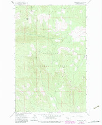
1963 Map of Warland Peak
USGS Topo · Published 1966About this map
The Kootenai National Forest of northwestern Montana dominates this mid-century topographic survey, centered on the high point of Warland Peak. A prominent Lookout Tower marks this summit, serving as a critical surveillance point for fire management within the forest's heavily timbered interior. The drainage patterns of the area are complex, with waters flowing through systems like Cripple Horse Creek and Weigel Creek, which carve deep valleys between peaks such as Weigel Mountain and Wolf Point.
Find a feature on this map
14 named features on this map. Tap any name to fly to it.
Don’t see what you’re looking for? This feature index may not catch every label — zoom into the map to look around manually.
Map Details
Editions of this 1963 Warland Peak Map
2 editions found
Other maps of this area

1913 · Stryker
USGS Topo · 1:125,000

1916 · Stryker
USGS Topo · 1:125,000

1920 · Jennings
USGS Topo · 1:125,000

1935 · Thompson Lakes
USGS Topo · 1:96,000

1942 · Thompson Lakes
USGS Topo · 1:125,000

1957 · Kalispell
USGS Topo · 1:250,000

1960 · Kalispell
USGS Topo · 1:250,000

1961 · Kalispell
USGS Topo · 1:250,000

1963 · Wolf Prairie
USGS Topo · 1:24,000

1963 · Davis Mountain
USGS Topo · 1:24,000