
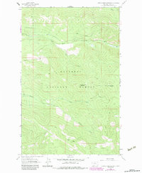
1963 Map of Cripple Horse Mountain
USGS Topo · Published 1966About this map
Kootenai National Forest dominates this mountain landscape in Lincoln County, defined by the drainage systems of Cripple Horse Creek and the North Fork Canyon Creek. The 1963 survey shows a terrain largely shaped by these waterways and steep elevations, with Cripple Horse Mountain and Boundary Mountain serving as primary landmarks. Human impact is restricted to a few isolated utility and transportation features, such as a Gravel Pit and segments of a Pack Trail that traverse the ridges. The prominence of Hornet Ridge and the network of creeks like Warland Creek and the South Fork illustrate a backcountry environment prior to significant modern development. This sheet is particularly useful for tracking the original topography and water courses of the northern Rockies before later twentieth-century modifications.
Find a feature on this map
11 named features on this map. Tap any name to fly to it.
Don’t see what you’re looking for? This feature index may not catch every label — zoom into the map to look around manually.
Map Details
Editions of this 1963 Cripple Horse Mountain Map
2 editions found
Other maps of this area

1920 · Jennings
USGS Topo · 1:125,000

1935 · Thompson Lakes
USGS Topo · 1:96,000

1942 · Thompson Lakes
USGS Topo · 1:125,000

1957 · Kalispell
USGS Topo · 1:250,000

1960 · Kalispell
USGS Topo · 1:250,000

1961 · Kalispell
USGS Topo · 1:250,000

1963 · Wolf Prairie
USGS Topo · 1:24,000

1963 · Davis Mountain
USGS Topo · 1:24,000

1963 · Warland Peak
USGS Topo · 1:24,000
1963 · Volcour
USGS Topo · 1:24,000