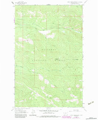
1963 Map of Cripple Horse Mountain
USGS Topo · Published 1984About this map
Kootenai National Forest dominates this mountain landscape in Lincoln County, where the topography is defined by the high divides of Cripple Horse Mountain and Boundary Mountain. The survey reveals a region managed for timber and resources during the early 1960s, punctuated by the early 1980s updates that reflect subtle changes in land use. Drainage patterns are intricate, with Cripple Horse Creek and Warland Creek carving through the northern sections while Canyon Creek and its tributary, North Fork Canyon Creek, cut through the southern reaches. Evidence of localized industry is found at a Gravel Pit near the creek. The area's transit is primarily limited to rugged routes like the Pack Trail, which winds along the western slopes of Hornet Ridge, illustrating the difficulty of traversing this interior mountain terrain before the widespread expansion of modern forest roads.
Find a feature on this map
11 named features on this map. Tap any name to fly to it.
Don’t see what you’re looking for? This feature index may not catch every label — zoom into the map to look around manually.
Map Details
Editions of this 1963 Cripple Horse Mountain Map
2 editions found
Other maps of this area

1920 · Jennings
USGS Topo · 1:125,000

1935 · Thompson Lakes
USGS Topo · 1:96,000

1942 · Thompson Lakes
USGS Topo · 1:125,000

1957 · Kalispell
USGS Topo · 1:250,000

1960 · Kalispell
USGS Topo · 1:250,000

1961 · Kalispell
USGS Topo · 1:250,000

1963 · Wolf Prairie
USGS Topo · 1:24,000

1963 · Davis Mountain
USGS Topo · 1:24,000

1963 · Warland Peak
USGS Topo · 1:24,000

1963 · Cripple Horse Mountain
USGS Topo · 1:24,000