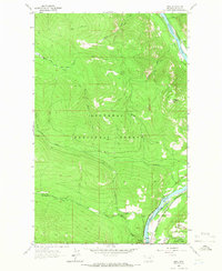
1963 Map of Ural
USGS Topo · Published 1966About this map
The Kootenai River carves a deep valley through the Kootenai National Forest in this 1963 survey of the Lincoln County panhandle. The Great Northern railroad hugs the eastern bank of the river, providing a critical transport link for the small riverside settlements of Ural and Warland. This period of the early 1960s captures the landscape before the construction of the Libby Dam, showing the original river course and the small-scale infrastructure that supported these timber and rail communities.
Find a feature on this map
24 named features on this map. Tap any name to fly to it.
Don’t see what you’re looking for? This feature index may not catch every label — zoom into the map to look around manually.
Map Details
Editions of this 1963 Ural Map
2 editions found
Other maps of this area

1920 · Jennings
USGS Topo · 1:125,000

1935 · Thompson Lakes
USGS Topo · 1:96,000

1942 · Thompson Lakes
USGS Topo · 1:125,000

1957 · Kalispell
USGS Topo · 1:250,000

1960 · Kalispell
USGS Topo · 1:250,000

1961 · Kalispell
USGS Topo · 1:250,000

1963 · Vermiculite Mountain
USGS Topo · 1:24,000

1963 · Mc Guire Mountain
USGS Topo · 1:24,000

1963 · Banfield Mountain
USGS Topo · 1:24,000

1963 · Cripple Horse Mountain
USGS Topo · 1:24,000