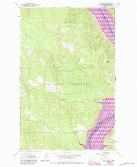
1963 Map of Ural Creek
USGS Topo · Published 1984About this map
Kootenai National Forest dominates this topographic study, where the landscape is defined by the significant hydrological changes along the Kootenai River. The map documents the creation of Lake Koocanusa, showing the normal pool elevation following the construction of the Libby Dam nearby. This era represents a major transition for the region, as riverfront terrain was permanently altered by the reservoir. High above the rising waters, Ziegler Mountain Lookout Tower stands as a sentinel over the steep drainages of Barron Creek and Bristow Creek. The network of Pack Trails winding through the mountains, including those near Sheep Creek and the East Branch South Fork Big Creek, illustrates the traditional access routes used before and during the mid-century forest management era.
Find a feature on this map
12 named features on this map. Tap any name to fly to it.
Don’t see what you’re looking for? This feature index may not catch every label — zoom into the map to look around manually.
Map Details
Editions of this 1963 Ural Creek Map
2 editions found
Other maps of this area

1920 · Jennings
USGS Topo · 1:125,000

1935 · Thompson Lakes
USGS Topo · 1:96,000

1942 · Thompson Lakes
USGS Topo · 1:125,000

1957 · Kalispell
USGS Topo · 1:250,000

1960 · Kalispell
USGS Topo · 1:250,000

1961 · Kalispell
USGS Topo · 1:250,000

1963 · Vermiculite Mountain
USGS Topo · 1:24,000

1963 · Mc Guire Mountain
USGS Topo · 1:24,000

1963 · Banfield Mountain
USGS Topo · 1:24,000

1963 · Cripple Horse Mountain
USGS Topo · 1:24,000