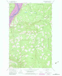
1963 Map of Beartrap Mountain
USGS Topo · Published 1984About this map
Kootenai National Forest dominates this mountain landscape, which was significantly altered by the creation of Lake Koocanusa. This 1963 survey, photorevised in 1983, documents the flooded canyon of the Kootenai River and the subsequent changes to the shoreline terrain. While high peaks like Beartrap Mountain and Helmer Mountain remain constant, the purple revision layers reveal the development of a Campground and the adjustment of local infrastructure around the new reservoir. The map traces a network of high-elevation trails, including a Pack Trail and Jeep Trail, that wind through drainage systems such as Pinkham Creek and Water Trough Draw. These routes provided access to small alpine bodies of water like Phills Lake and Rock Lake, reflecting the shift from early resource extraction, noted by a Gravel Pit, toward recreational and forest management use in the late twentieth century.
Find a feature on this map
19 named features on this map. Tap any name to fly to it.
Don’t see what you’re looking for? This feature index may not catch every label — zoom into the map to look around manually.
Map Details
Editions of this 1963 Beartrap Mountain Map
2 editions found
Other maps of this area

1957 · Kalispell
USGS Topo · 1:250,000

1960 · Kalispell
USGS Topo · 1:250,000

1961 · Kalispell
USGS Topo · 1:250,000

1963 · Rexford
USGS Topo · 1:24,000

1963 · Eureka North
USGS Topo · 1:24,000

1963 · Mc Guire Mountain
USGS Topo · 1:24,000

1963 · Eureka South
USGS Topo · 1:24,000

1963 · Red Mountain
USGS Topo · 1:24,000

1963 · Webb Mountain
USGS Topo · 1:24,000
1963 · Pinkham Mountain
USGS Topo · 1:24,000