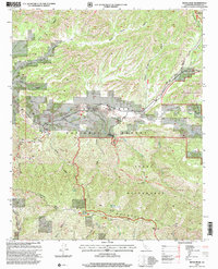
1995 Map of Reyes Peak
USGS Topo · Published 2000About this map
Pine Mountain and Reyes Peak dominate the high-elevation terrain in this mid-1990s record of Ventura County’s interior. The landscape is defined by the sharp transition between the Cuyama River valley and the high ridgelines of the Los Padres National Forest. Human settlement is sparse and concentrated along Lockwood Valley Road, notably at Ozena and the nearby Ozena Fire Station. Further east, the small community of Camp Scheideck sits tucked along the Reyes Creek Scenic Byway, providing access to the more remote backcountry. Significant portions of the sheet are dedicated to the Sespe Wilderness and the Chumash Wilderness, where an extensive network of trails and campsites, such as Raspberry Campsite and Beartrap Campsite, highlights the region's importance for resource management and recreation.
Find a feature on this map
48 named features on this map. Tap any name to fly to it.
Don’t see what you’re looking for? This feature index may not catch every label — zoom into the map to look around manually.
Map Details
Editions of this 1995 Reyes Peak Map
This is the sole edition of this map. No revisions or reprints were ever made.
Other maps of this area

1903 · Mt. Pinos
USGS Topo · 1:125,000

1942 · Wheeler Springs
USGS Topo · 1:24,000

1943 · Rancho Nuevo Creek
USGS Topo · 1:24,000

1943 · Old Man Mountain
USGS Topo · 1:24,000

1943 · Apache Canyon
USGS Topo · 1:24,000

1943 · San Guillermo
USGS Topo · 1:24,000

1943 · Sawmill Mountain
USGS Topo · 1:24,000

1943 · Cuyama Peak
USGS Topo · 1:24,000

1943 · Lion Canyon
USGS Topo · 1:24,000

1943 · Reyes Peak
USGS Topo · 1:24,000