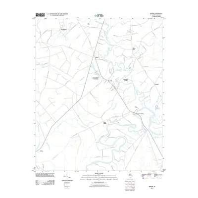
2011 Map of Rhems
USGS Topo · Published 2011About this map
The Black Mingo Creek and the Black River converge in this low-lying region of Georgetown County, where water shapes the history of settlement and transport. Local genealogy is anchored by the Black Mingo Cemetery, Wilson Cemetery, and Wallace Cemetery, which serve the small communities of Dorseytown, Rhems, and Willie Towne. The map documents a transition point for river travel at Browns Ferry and the nearby Browns Ferry Bridge, marking a longstanding crossing over the wide river channels. In the north, Black Mingo Creek winds through a landscape of named wetlands including Smith Swamp and Burnett Swamp, while the Tara Hall school stands near the creek's lower reach. This survey highlights the traditional landings and ferry points, like Cow Head Landing, that once connected these timber-rich and agricultural lands before modern road networks were fully established.
Find a feature on this map
101 named features on this map. Tap any name to fly to it.
Don’t see what you’re looking for? This feature index may not catch every label — zoom into the map to look around manually.
Map Details
Editions of this 2011 Rhems Map
This is the sole edition of this map. No revisions or reprints were ever made.
Other maps of this area

1943 · Olin
USGS Topo · 1:31,680

1943 · Henry
USGS Topo · 1:24,000

1943 · Carvers Bay
USGS Topo · 1:24,000

1943 · Rhems
USGS Topo · 1:24,000

1943 · Andrews
USGS Topo · 1:24,000

1943 · Georgetown North
USGS Topo · 1:24,000

1943 · Outland
USGS Topo · 1:24,000

1944 · Outland
USGS Topo · 1:31,680

1946 · Indiantown
USGS Topo · 1:62,500

1949 · Georgetown
USGS Topo · 1:250,000