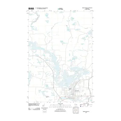
2010 Map of Rhinelander
USGS Topo · Published 2010About this map
The Wisconsin River winds through the heart of Rhinelander at the start of the 21st century, serving as the defining geographical feature for this Oneida County hub. This 2010 topographic map shows the city's infrastructure in detail, including the Rhinelander 1907C280 Dam and the Rhinelander Post Office. The surrounding landscape is dominated by a dense network of glacial lakes and waterways, from the recreational grounds of Camp Tesomas near Crystal Lake to the scattered basins of Pine Lake, Pickerel Lake, and Silver Lake. The development of the city is balanced against these natural features, with the Rhinelander-Oneida County Airport situated to the southwest. Transport and utility patterns are evident in the layout of the Rhinelander Wastewater Treatment Facility and the numerous named creeks like Newbold Creek and Skunk Creek that feed into the larger river system.
Find a feature on this map
43 named features on this map. Tap any name to fly to it.
Don’t see what you’re looking for? This feature index may not catch every label — zoom into the map to look around manually.
Map Details
Editions of this 2010 Rhinelander Map
This is the sole edition of this map. No revisions or reprints were ever made.
Other maps of this area

1930 · Robbins
USGS Topo · 1:48,000

1938 · Minocqua
USGS Topo · 1:48,000

1938 · Robbins
USGS Topo · 1:48,000

1939 · Cassian
USGS Topo · 1:48,000

1940 · Rhinelander
USGS Topo · 1:48,000

1942 · Cassian
USGS Topo · 1:48,000

1945 · Robbins
USGS Topo · 1:48,000

1946 · Minocqua
USGS Topo · 1:48,000

1949 · Rhinelander
USGS Topo · 1:48,000

1949 · Minocqua
USGS Topo · 1:48,000