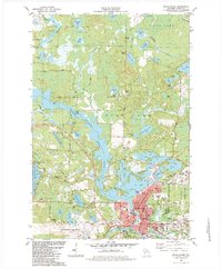
1982 Map of Rhinelander
USGS Topo · Published 1983About this map
The city of Rhinelander serves as the focal point of this Northwoods landscape, situated where the Wisconsin River forms extensive flowages and connects a dense network of glacial lakes. In the early 1980s, the area's development is centered around its civic and educational infrastructure, including Central School, the Hospital, and City Hall. The shoreline of Boom Lake and the Wisconsin River Flowage dominate the central topography, while the Chicago and Northwestern railroad and an old railroad grade trace the historic transit routes through the timbered terrain. Further north, the landscape transitions into the town of Pine Lake and Sugar Camp, characterized by scout camps like Camp Tesomas and dozens of water bodies such as Silver Lake and Pickerel Lake. For genealogists, the map preserves the locations of St Marys Cemetery and Forest Home Cemetery, along with neighborhood landmarks like St Josephs Church and Newbold School.
Find a feature on this map
79 named features on this map. Tap any name to fly to it.
Don’t see what you’re looking for? This feature index may not catch every label — zoom into the map to look around manually.
Map Details
Editions of this 1982 Rhinelander Map
This is the sole edition of this map. No revisions or reprints were ever made.
Other maps of this area

1930 · Robbins
USGS Topo · 1:48,000

1938 · Minocqua
USGS Topo · 1:48,000

1938 · Robbins
USGS Topo · 1:48,000

1939 · Cassian
USGS Topo · 1:48,000

1940 · Rhinelander
USGS Topo · 1:48,000

1942 · Cassian
USGS Topo · 1:48,000

1945 · Robbins
USGS Topo · 1:48,000

1946 · Minocqua
USGS Topo · 1:48,000

1949 · Rhinelander
USGS Topo · 1:48,000

1949 · Minocqua
USGS Topo · 1:48,000