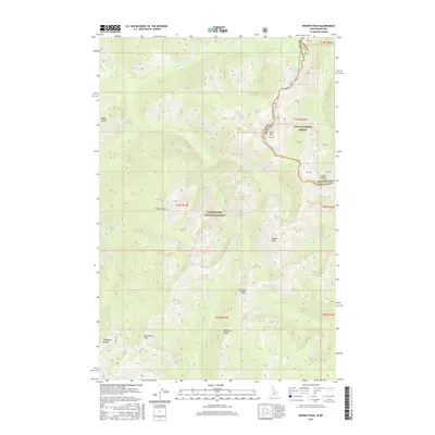
2017 Map of Rhodes Peak
USGS Topo · Published 2017About this map
Rhodes Peak dominates the center of this high-elevation landscape along the border of Mineral and Clearwater Counties. The Continental Divide serves as a natural boundary between the Lolo National Forest in Montana and the Clearwater National Forest in Idaho. This segment of the Bitterroot Mountains is defined by sharp peaks and high-alpine basins, where water features such as Smokey Lake, Leo Lake, and Goat Lake gather in the shadows of summits like Shale Mtn and Williams Peak. The intricate drainage systems of the Middle Fork Kelly Creek and Cayuse Creek illustrate the source waters for the larger regional watersheds. The naming of landmarks like Kellys Sister and Kellys Finger suggests the early influence of trappers or surveyors who moved through these summits long before the establishment of modern forest boundaries.
Find a feature on this map
36 named features on this map. Tap any name to fly to it.
Don’t see what you’re looking for? This feature index may not catch every label — zoom into the map to look around manually.
Map Details
Editions of this 2017 Rhodes Peak Map
This is the sole edition of this map. No revisions or reprints were ever made.
Other maps of this area

1911 · Lolo
USGS Topo · 1:250,000

1913 · Lolo
USGS Topo · 1:250,000

1956 · Hamilton
USGS Topo · 1:250,000

1959 · Hamilton
USGS Topo · 1:250,000

1960 · Hamilton
USGS Topo · 1:250,000

1960 · Straight Peak
USGS Topo · 1:62,500

1964 · Hamilton
USGS Topo · 1:250,000

1964 · Rocky Point
USGS Topo · 1:24,000
1964 · White Mountain
USGS Topo · 1:24,000
1964 · Granite Pass
USGS Topo · 1:24,000