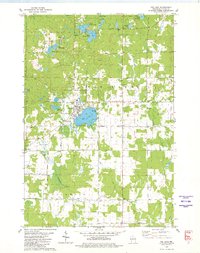
1945 Map of Rib Lake
USGS Topo · Published 1945About this map
The North Fork Spirit River and its numerous tributaries define this 1945 landscape at the intersection of Taylor, Price, and Lincoln Counties. The geography is dominated by glacial kettle lakes and wetlands, including Spirit Lake, Tims Lake, and Stone Lake. While the map lacks major urban centers, it details a robust network of rural social infrastructure from the early 1940s. A dozen small district schools like Ring Sch, Spirit Center Sch, and Liberty Sch are scattered across the townships of Spirit, Prentice, and Hill.
Find a feature on this map
51 named features on this map. Tap any name to fly to it.
Don’t see what you’re looking for? This feature index may not catch every label — zoom into the map to look around manually.
Map Details
Editions of this 1945 Rib Lake Map
This is the sole edition of this map. No revisions or reprints were ever made.
Historical Maps of Rib Lake Through Time
5 maps found