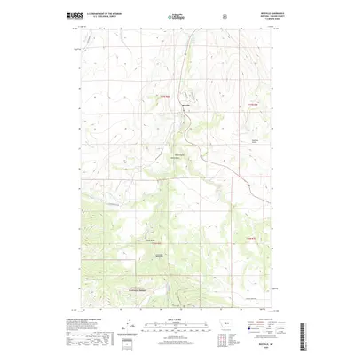
2020 Map of Riceville
USGS Topo · Published 2020About this map
Riceville serves as the central point of interest in this section of Cascade County, where the terrain transitions into the steep slopes of the Little Belt Mountains. The landscape is defined by the winding course of Belt Creek, which has carved out significant geological features like the Sluice Boxes and Nasen Coulee. Much of the southern and western portions of the quadrangle are contained within the Lewis & Clark National Forest, protecting high-elevation landmarks such as Crown Butte. Local hydrology is marked by numerous drainage systems including Tiger Creek and Pilgrim Creek, along with named water sources like Isaac Walton Spring. The map documents a network of mountain roads, such as Evans Riceville Rd and Logging Creek Rd, which provide access to the timbered gulches and coulees that characterize this part of Montana.
Find a feature on this map
25 named features on this map. Tap any name to fly to it.
Don’t see what you’re looking for? This feature index may not catch every label — zoom into the map to look around manually.
Map Details
Editions of this 2020 Riceville Map
This is the sole edition of this map. No revisions or reprints were ever made.
Other maps of this area

1886 · Great Falls
USGS Topo · 1:250,000

1890 · Fort Benton
USGS Topo · 1:250,000

1892 · Fort Benton
USGS Topo · 1:250,000

1897 · Fort Benton
USGS Topo · 1:250,000

1954 · Great Falls
USGS Topo · 1:250,000

1955 · Stockett
USGS Topo · 1:62,500

1956 · Belt
USGS Topo · 1:62,500

1957 · Great Falls
USGS Topo · 1:250,000

1965 · Mahoney Hill
USGS Topo · 1:24,000
1967 · Monarch NE
USGS Topo · 1:24,000