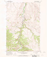
1967 Map of Riceville
USGS Topo · Published 1970About this map
Riceville sits at the heart of this mid-century survey, positioned along the winding course of Belt Creek. The landscape is defined by its industrial and recreational history, prominently featuring the Sluice Boxes Railroad Grade and an Old Railroad Grade that follow the creek's narrow corridor. These paths hint at a former rail-dependent economy within the steep canyon walls, where Gaging Sta monitored the water flow near Camp Don Bosco.
Find a feature on this map
22 named features on this map. Tap any name to fly to it.
Don’t see what you’re looking for? This feature index may not catch every label — zoom into the map to look around manually.
Map Details
Editions of this 1967 Riceville Map
This is the sole edition of this map. No revisions or reprints were ever made.
Other maps of this area

1886 · Great Falls
USGS Topo · 1:250,000

1890 · Fort Benton
USGS Topo · 1:250,000

1892 · Fort Benton
USGS Topo · 1:250,000

1897 · Fort Benton
USGS Topo · 1:250,000

1954 · Great Falls
USGS Topo · 1:250,000

1955 · Stockett
USGS Topo · 1:62,500

1956 · Belt
USGS Topo · 1:62,500

1957 · Great Falls
USGS Topo · 1:250,000

1965 · Mahoney Hill
USGS Topo · 1:24,000
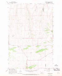
1967 · Monarch NE
USGS Topo · 1:24,000