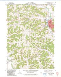
1983 Map of Richland Center
USGS Topo · Published 1983About this map
Richland Center serves as the focal point for this survey, situated where the Pine River meets a complex network of ridges and hollows. The urban core is well-defined by the Wisconsin Western railroad and institutions like the U of Wis Center-Richland and Richland Middle Sch. Beyond the city limits, the landscape transitions into the agricultural and wooded uplands of Dayton and Orion townships, where family-named landmarks like Kestrel Ridge and Oak Ridge dominate the topography. The southern portion of the map includes the northern edge of the Lower Wisconsin River State Wildlife Area, indicating a shift toward conservation at the edge of the river valley. Scattered cemeteries, including Bethel Cem and Brown Cem, offer genealogical anchor points for researchers tracing the rural families of Richland County during the early 1980s.
Find a feature on this map
60 named features on this map. Tap any name to fly to it.
Don’t see what you’re looking for? This feature index may not catch every label — zoom into the map to look around manually.
Map Details
Editions of this 1983 Richland Center Map
This is the sole edition of this map. No revisions or reprints were ever made.
Other maps of this area

1905 · Richland Center
USGS Topo · 1:125,000

1933 · Boaz
USGS Topo · 1:62,500

1933 · Boscobel
USGS Topo · 1:62,500

1958 · La Crosse
USGS Topo · 1:250,000

1960 · Richland Center
USGS Topo · 1:62,500

1960 · Muscoda
USGS Topo · 1:62,500

1961 · La Crosse
USGS Topo · 1:250,000

1965 · La Crosse
USGS Topo · 1:250,000

1966 · Boaz
USGS Topo · 1:62,500
1967 · Boscobel
USGS Topo · 1:62,500