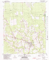
1981 Map of Richlands
USGS Topo · Published 1981About this map
The New River headwaters and a network of swampy tributaries define the landscape of this coastal plain region during the late 1970s and early 1980s. The town of Richlands serves as the primary hub, surrounded by smaller agrarian settlements such as Huffmantown, Petersburg, and Ervintown. The presence of numerous small family or community cemeteries (marked simply as Cem) throughout the countryside provides a significant resource for genealogists mapping ancestral landholdings.
Find a feature on this map
59 named features on this map. Tap any name to fly to it.
Don’t see what you’re looking for? This feature index may not catch every label — zoom into the map to look around manually.
Map Details
Editions of this 1981 Richlands Map
This is the sole edition of this map. No revisions or reprints were ever made.
Other maps of this area

1903 · Trent River
USGS Topo · 1:62,500

1904 · Trent River
USGS Topo · 1:62,500

1943 · Jacksonville
USGS Topo · 1:62,500

1948 · Richlands
USGS Topo · 1:62,500

1953 · Rocky Mount
USGS Topo · 1:250,000

1953 · Beaufort
USGS Topo · 1:250,000

1954 · Rocky Mount
USGS Topo · 1:250,000

1954 · Beaufort
USGS Topo · 1:250,000

1958 · Deep Run
USGS Topo · 1:62,500

1965 · Richlands
USGS Topo · 1:62,500