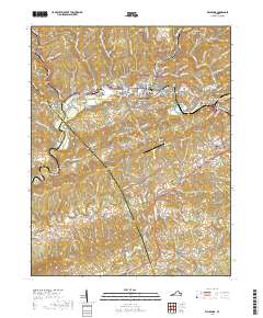
2019 Map of Richlands
USGS Topo · Published 2019About this map
Richlands and its surrounding mountain ridges anchor this 2019 study of the Tazewell and Russell county border. The Clinch River and Little River wind through a landscape defined by industrial and residential growth along the Norfolk Southern rail corridor. Significant local landmarks including the Southwest Virginia Community College and Tazewell County Airport sit alongside residential pockets like Cedar Bluff, Claypool Hill, and Raven. For genealogists, several burial sites are documented, such as Hankins Cem and William Vance Cem, while the Clinch Valley Memorial Cem marks the edge of Doran. The topography is particularly detailed, showing the steep relief of Stone Mtn and the distinctively named House and Barn Mtn south of Clifton. Long-distance paths like the Trl of the Lonesome Pine trace the historic routes over these Appalachian ridges.
Find a feature on this map
79 named features on this map. Tap any name to fly to it.
Don’t see what you’re looking for? This feature index may not catch every label — zoom into the map to look around manually.
Map Details
Editions of this 2019 Richlands Map
This is the sole edition of this map. No revisions or reprints were ever made.
Other maps of this area

1891 · Tazewell
USGS Topo · 1:125,000

1891 · Abingdon
USGS Topo · 1:125,000

1894 · Abingdon
USGS Topo · 1:125,000

1895 · Tazewell
USGS Topo · 1:125,000

1897 · Tazewell
USGS Topo · 1:125,000

1909 · Abingdon
USGS Topo · 1:96,000

1911 · Abingdon
USGS Topo · 1:125,000

1912 · Pounding Mill
USGS Topo · 1:62,500

1915 · Richlands
USGS Topo · 1:48,000

1916 · Pounding Mill
USGS Topo · 1:62,500