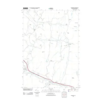
2012 Map of Richmond
USGS Topo · Published 2012About this map
The Winooski River corridor anchors the southern portion of this region, where the settlements of Richmond and Jonesville are situated. The landscape transitions from these riverfront villages into a complex network of hills and hollows, including Talbot Hollow and the distinctive Birnies Nose. Local history is preserved in numerous burial grounds across the area, from the Old Village Cem near the river to the upland West Bolton Cem. To the north, Jericho Center and Nashville serve as historic nodes within a terrain defined by the Lee River and Mill Brook. Large tracts of land are dedicated to various uses, such as the Camp Ethan Allen Trng Site and Camp Underhill in the northeast, alongside recreational spaces like the West Bolton Golf Course. The map traces a mix of traditional road names, such as Browns Trace Rd and Ethan Allen Rd, illustrating the intersection of modern transit and historical thoroughfares.
Find a feature on this map
98 named features on this map. Tap any name to fly to it.
Don’t see what you’re looking for? This feature index may not catch every label — zoom into the map to look around manually.
Map Details
Editions of this 2012 Richmond Map
This is the sole edition of this map. No revisions or reprints were ever made.
Other maps of this area

1906 · Burlington
USGS Topo · 1:62,500

1913 · Milton
USGS Topo · 1:48,000

1915 · Milton
USGS Topo · 1:62,500

1919 · Burlington
USGS Topo · 1:62,500

1921 · Richmond
USGS Topo · 1:48,000

1924 · Camels Hump
USGS Topo · 1:62,500

1925 · Mount Mansfield
USGS Topo · 1:48,000

1927 · Mount Mansfield
USGS Topo · 1:62,500

1944 · Milton
USGS Topo · 1:62,500

1944 · Mount Mansfield
USGS Topo · 1:62,500