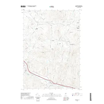
2018 Map of Richmond
USGS Topo · Published 2018About this map
The Winooski River carves a significant path through this Chittenden County landscape, establishing a natural corridor for the Jonesville settlement and the historical crossing at Edmond Bridge. This modern topographic study reveals the elevation contrasts between the river valley and the rising peaks of the Green Mountains, including landmarks like The Cobble and Huckleberry Hill. The map documents a cluster of village centers including Jericho Center and Nashville, connected by a network of rural roads such as Cochran Rd and Stage Rd. Genealogists will find several burial sites clearly marked, from the centrally located Richmond Village Cem and Saint Marys Cem to the more isolated West Bolton Cem near Mill Brook. The inclusion of the Meadow Airport and the residential expansion around Richmond Pond illustrates the area's contemporary development within its traditional agricultural and mountainous framework.
Find a feature on this map
93 named features on this map. Tap any name to fly to it.
Don’t see what you’re looking for? This feature index may not catch every label — zoom into the map to look around manually.
Map Details
Editions of this 2018 Richmond Map
This is the sole edition of this map. No revisions or reprints were ever made.
Other maps of this area

1906 · Burlington
USGS Topo · 1:62,500

1913 · Milton
USGS Topo · 1:48,000

1915 · Milton
USGS Topo · 1:62,500

1919 · Burlington
USGS Topo · 1:62,500

1921 · Richmond
USGS Topo · 1:48,000

1924 · Camels Hump
USGS Topo · 1:62,500

1925 · Mount Mansfield
USGS Topo · 1:48,000

1927 · Mount Mansfield
USGS Topo · 1:62,500

1944 · Milton
USGS Topo · 1:62,500

1944 · Mount Mansfield
USGS Topo · 1:62,500