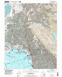
1995 Map of Richmond
USGS Topo · Published 1999About this map
The industrialized shoreline of Richmond and the East Bay hills meet in this mid-1990s perspective, showing a landscape defined by sharp topographical contrasts and established urban boundaries. Dense residential grids in El Cerrito and Albany transition into the steep terrain of the Berkeley Hills and San Pablo Ridge, where the sprawling Charles Lee Tilden Regional Park and the San Pablo Reservoir provide a massive buffer of undeveloped land. Along the waterfront, the commercial legacy of the Richmond Inner Harbor and Point Potrero is visible alongside newer developments like Richmond Marina Bay. Educational and institutional landmarks, including University of California grounds and Contra Costa College, anchor the various communities from Berkeley north to San Pablo. Transportation corridors such as Interstate 80 and the Southern Pacific tracks weave through the valleys, connecting the ports to the growing suburban enclaves of El Sobrante and Pinole.
Find a feature on this map
52 named features on this map. Tap any name to fly to it.
Don’t see what you’re looking for? This feature index may not catch every label — zoom into the map to look around manually.
Map Details
Editions of this 1995 Richmond Map
This is the sole edition of this map. No revisions or reprints were ever made.
Other maps of this area

1895 · San Francisco
USGS Topo · 1:62,500

1896 · Carquinez Strait
USGS Topo · 1:62,500

1897 · Concord
USGS Topo · 1:62,500

1898 · Karquines
USGS Topo · 1:62,500

1899 · San Francisco
USGS Topo · 1:62,500

1901 · Karquines
USGS Topo · 1:62,500

1902 · Napa
USGS Topo · 1:125,000

1915 · Concord
USGS Topo · 1:62,500

1915 · San Francisco
USGS Topo · 1:62,500

1916 · Mare Island
USGS Topo · 1:62,500