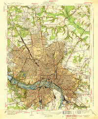
1939 Map of Richmond
USGS Topo · Published 1939About this map
The James River serves as the central artery for this capital city landscape, where established neighborhoods like Ginter Park and Windsor Farms meet a dense network of industrial and institutional landmarks. Surveyed in the mid-1930s, the map reveals a city defined by its complex transportation infrastructure, from the Richmond Fredericksburg and Potomac RR rail yards at Acca to the heavy rail corridors of the Southern Ry and Chesapeake and Ohio RR. The urban core is surrounded by significant cultural sites, including the Confederate Soldiers Home, Union Seminary, and the Carillon. Extensive cemetery grounds such as Hollywood Cemetery, Oakwood Cemetery, and Evergreen Cemetery provide critical data for genealogists. The map also documents the transition from urban to rural at the city's edge, noted by the Pine Camp Sanatorium and the Westbrook Sanitarium, illustrating the spatial organization of social and medical services during this era.
Find a feature on this map
96 named features on this map. Tap any name to fly to it.
Don’t see what you’re looking for? This feature index may not catch every label — zoom into the map to look around manually.
Map Details
Editions of this 1939 Richmond Map
2 editions found

Other maps of this area

1890 · Goochland
USGS Topo · 1:125,000

1892 · Goochland
USGS Topo · 1:125,000

1894 · Bermuda Hundred
USGS Topo · 1:62,500

1894 · Richmond
USGS Topo · 1:62,500

1895 · Richmond
USGS Topo · 1:62,500

1897 · Amelia
USGS Topo · 1:125,000

1934 · Seven Pines
USGS Topo · 1:24,000

1934 · Richmond
USGS Topo · 1:24,000

1936 · Richmond West
USGS Topo · 1:24,000

1936 · Glen Allen
USGS Topo · 1:24,000