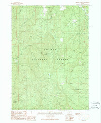
1989 Map of Richter Mountain
USGS Topo · Published 1990About this map
Umpqua National Forest defines this high-elevation landscape along the border of Douglas and Jackson counties. The terrain is deeply incised by the drainage systems of South Fork Cow Creek, East Fork Cow Creek, and Drew Creek. Mining activity is a significant historical marker on the land, evidenced by the Banfield Mine near the center of the sheet and the Rowley Mine to the south. Further exploration reveals the Mammoth Lobe Mine situated on the slopes of Richter Mountain. This era of the late 1980s shows a network of 4wd tracks and forest roads providing access to remote points like Peavine Camp and Richter Cabin. The presence of these named sites, alongside landmarks such as Tombstone Gap and Threehorn Mountain, provides essential geographic context for those researching the industrial and recreational history of the southern Oregon Cascades.
Find a feature on this map
40 named features on this map. Tap any name to fly to it.
Don’t see what you’re looking for? This feature index may not catch every label — zoom into the map to look around manually.
Map Details
Editions of this 1989 Richter Mountain Map
This is the sole edition of this map. No revisions or reprints were ever made.
Other maps of this area

1891 · Ashland
USGS Topo · 1:250,000

1893 · Ashland
USGS Topo · 1:250,000

1897 · Ashland
USGS Topo · 1:250,000

1904 · Riddle
USGS Topo · 1:125,000

1943 · Trail
USGS Topo · 1:62,500

1944 · Tiller
USGS Topo · 1:62,500

1954 · Days Creek
USGS Topo · 1:62,500

1954 · Wimer
USGS Topo · 1:62,500

1955 · Medford
USGS Topo · 1:250,000

1957 · Medford
USGS Topo · 1:250,000