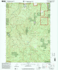
1998 Map of Richter Mountain
USGS Topo · Published 2000About this map
Banfield Mine and the Red Cloud Mine sit within this steep terrain, reflecting the mid-to-late 20th-century mining and timber focus of this section of the Umpqua National Forest. The landscape is defined by its industrial and recreational intersections, featuring sites like the Mammoth Lode Mine alongside isolated landmarks such as the Richter Cabin and Peavine Camp. Water sources like Drew Lake and the South Fork White Creek cut through the topography, which is anchored by high points like Richter Mountain and Threehorn Mountain. This 1990s revision reveals a network of forest roads and 4WD trails that provided access to these remote resource sites and small outposts like Stauch Ranch near the Douglas and Jackson county line.
Find a feature on this map
38 named features on this map. Tap any name to fly to it.
Don’t see what you’re looking for? This feature index may not catch every label — zoom into the map to look around manually.
Map Details
Editions of this 1998 Richter Mountain Map
This is the sole edition of this map. No revisions or reprints were ever made.
Other maps of this area

1891 · Ashland
USGS Topo · 1:250,000

1893 · Ashland
USGS Topo · 1:250,000

1897 · Ashland
USGS Topo · 1:250,000

1904 · Riddle
USGS Topo · 1:125,000

1943 · Trail
USGS Topo · 1:62,500

1944 · Tiller
USGS Topo · 1:62,500

1954 · Days Creek
USGS Topo · 1:62,500

1954 · Wimer
USGS Topo · 1:62,500

1955 · Medford
USGS Topo · 1:250,000

1957 · Medford
USGS Topo · 1:250,000