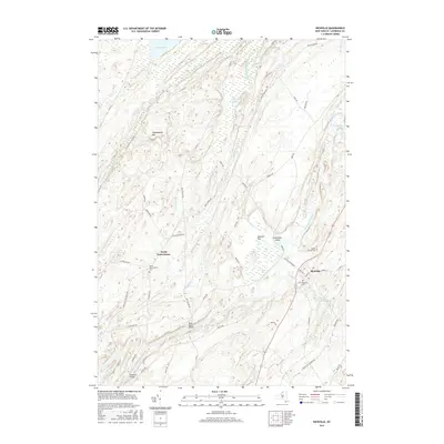
2016 Map of Richville
USGS Topo · Published 2016About this map
The Oswegatchie River meanders across this Saint Lawrence County landscape, defining the character of the settlements at Richville and North Gouverneur. This survey captures the rural infrastructure of Northern New York, where historic crossing points like Rock Island Bridge and Peabody Bridge connect a network of remote roads including Lead Mine RD and Cream Of The Valley RD. The terrain is marked by significant wetlands and water bodies, from Mud Lake in the north to the glacial features of Osborn Lake and Spooner Flat. Genealogists will find notable local landmarks in the North Gouverneur Cem, Maple Grove Cem, and Wayside Cem, providing a clear record of the area's established community centers. The geography transitions from the elevations of Huckleberry Mtn to the fertile basins carved by Beaver Creek and its southern branch, illustrating the persistent agricultural and river-based layout of the region.
Find a feature on this map
57 named features on this map. Tap any name to fly to it.
Don’t see what you’re looking for? This feature index may not catch every label — zoom into the map to look around manually.
Map Details
Editions of this 2016 Richville Map
This is the sole edition of this map. No revisions or reprints were ever made.
Other maps of this area

1904 · Ogdensburg
USGS Topo · 1:62,500

1905 · Ogdensburg
USGS Topo · 1:62,500

1906 · Brier Hill
USGS Topo · 1:62,500

1912 · Hammond
USGS Topo · 1:62,500

1915 · Gouverneur
USGS Topo · 1:62,500

1937 · Gouverneur
USGS Topo · 1:62,500

1943 · Rensselaer Falls
USGS Topo · 1:31,680

1943 · Edwardsville
USGS Topo · 1:31,680
1943 · Heuvelton
USGS Topo · 1:31,680

1944 · Hammond
USGS Topo · 1:62,500