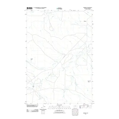
2011 Map of Ridgway
USGS Topo · Published 2011About this map
Ridgeway serves as the central anchor for this remote Carter County landscape, where the high plains of southeastern Montana are defined by an intricate network of drainage systems. The terrain is marked by the winding paths of Corral Creek in the north and the confluence of Boxelder Creek and Muskrat Creek toward the center. This 2011 survey highlights the critical role of water management in this arid ranching country, evidenced by specifically named earthen structures like Blackford Number 3 Dam and R Owen Number 1 Dam. These features, alongside Blackford Number 5 Dam, underscore the local reliance on captured runoff for livestock and agriculture. Isolated roads such as Old Hammond Rd and Ridge Rd provide the primary transit through the grasslands, connecting the scattered water resources and the small settlement of Ridgeway to the broader county.
Find a feature on this map
15 named features on this map. Tap any name to fly to it.
Don’t see what you’re looking for? This feature index may not catch every label — zoom into the map to look around manually.
Map Details
Editions of this 2011 Ridgway Map
This is the sole edition of this map. No revisions or reprints were ever made.
Other maps of this area

1954 · Ekalaka
USGS Topo · 1:250,000

1956 · Ekalaka
USGS Topo · 1:250,000

1958 · Ekalaka
USGS Topo · 1:250,000

1965 · Ekalaka
USGS Topo · 1:250,000

1979 · Dutchman Creek
USGS Topo · 1:24,000

1979 · Ikey Creek
USGS Topo · 1:24,000

1980 · Prairie Dog Creek
USGS Topo · 1:24,000
1980 · School Section Creek
USGS Topo · 1:24,000
1980 · Finger Buttes West
USGS Topo · 1:24,000

1981 · Alzada
USGS Topo · 1:100,000