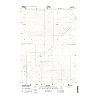
2017 Map of Ridgway
USGS Topo · Published 2017About this map
Ridgeway serves as the central point of reference in this southeastern Montana landscape, situated within a high-plains environment defined by a dense network of intermittent drainage systems. The terrain is intricately carved by several watercourses, including the central Boxelder Cr and its tributaries, Muskrat Cr and Whitetail Cr. These drainages, along with Corral Cr to the north and Hawksnest Cr to the east, dictate the movement and layout of the local road system. Transportation through this part of Carter County is maintained via routes such as Hammond Rd, which provides a long-distance connection across the township boundaries of t4s r58e and t5s r58e. The placement of Tauck Rd and Hopkins Rd suggests a landscape organized around rural homesteads and ranching access, characteristic of the region's contemporary land use patterns.
Find a feature on this map
15 named features on this map. Tap any name to fly to it.
Don’t see what you’re looking for? This feature index may not catch every label — zoom into the map to look around manually.
Map Details
Editions of this 2017 Ridgway Map
This is the sole edition of this map. No revisions or reprints were ever made.
Other maps of this area

1954 · Ekalaka
USGS Topo · 1:250,000

1956 · Ekalaka
USGS Topo · 1:250,000

1958 · Ekalaka
USGS Topo · 1:250,000

1965 · Ekalaka
USGS Topo · 1:250,000

1979 · Dutchman Creek
USGS Topo · 1:24,000

1979 · Ikey Creek
USGS Topo · 1:24,000

1980 · Prairie Dog Creek
USGS Topo · 1:24,000
1980 · School Section Creek
USGS Topo · 1:24,000
1980 · Finger Buttes West
USGS Topo · 1:24,000

1981 · Alzada
USGS Topo · 1:100,000