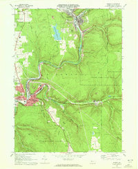
1969 Map of Ridgway
USGS Topo · Published 1972About this map
The industrial and riverine character of Elk County is clearly defined along the winding Clarion River, where the borough of Ridgway serves as a primary hub for commerce and transport. In the late 1960s, the area's economic base is visible through a dense network of infrastructure, including the Penn Central railroad and numerous extractive sites like the Strip Mine and Claypit. Local life is anchored by several long-standing institutions, such as St Leos Sch, Centennial Sch, and a series of burial grounds including Oakmont Cem and Pine Grove Cem.
Find a feature on this map
59 named features on this map. Tap any name to fly to it.
Don’t see what you’re looking for? This feature index may not catch every label — zoom into the map to look around manually.
Map Details
Editions of this 1969 Ridgway Map
3 editions found
Other maps of this area

1934 · Kane
USGS Topo · 1:48,000

1935 · Mt. Jewett
USGS Topo · 1:48,000

1939 · Kane
USGS Topo · 1:62,500

1940 · Hallton
USGS Topo · 1:48,000

1940 · Mt. Jewett
USGS Topo · 1:62,500

1941 · Ridgway
USGS Topo · 1:62,500

1943 · Hallton
USGS Topo · 1:62,500

1944 · Ridgway
USGS Topo · 1:62,500

1957 · Warren
USGS Topo · 1:250,000

1958 · Warren
USGS Topo · 1:250,000