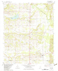
1982 Map of Rienzi
USGS Topo · Published 1983About this map
Rienzi and Biggersville anchor this survey of northeast Mississippi, where the Gulf Central Illinois railroad and the Tuscumbia River define the local geography. The landscape is dense with small rural settlements and religious sites like Wesley Chapel and Wheeler Grove Ch, reflecting the deep-rooted community structure of the Alcorn and Prentiss county line. Significant genealogical resources are documented throughout, including the Old Danville Cem, Stockade Cem, and the Dilworth Cems. The mapping reveals a detailed water system of creeks and small lakes, such as Mays Creek, Bynum Creek, and Mitchel Lake, which carved the terrain long before modern infrastructure. These drainage patterns influenced the placement of early homesteads and landmarks like Kimmons Hill and Rogers Hill, while the Tuscumbia River corridor remains a central natural feature of the area.
Find a feature on this map
45 named features on this map. Tap any name to fly to it.
Don’t see what you’re looking for? This feature index may not catch every label — zoom into the map to look around manually.
Map Details
Editions of this 1982 Rienzi Map
This is the sole edition of this map. No revisions or reprints were ever made.
Other maps of this area

1921 · Booneville
USGS Topo · 1:48,000

1922 · Booneville
USGS Topo · 1:62,500

1935 · Glens
USGS Topo · 1:24,000

1936 · Kendrick
USGS Topo · 1:24,000

1950 · Corinth
USGS Topo · 1:62,500

1950 · Kendrick
USGS Topo · 1:24,000

1950 · Glens
USGS Topo · 1:24,000

1950 · Altitude
USGS Topo · 1:24,000

1956 · Tupelo
USGS Topo · 1:250,000

1958 · Tupelo
USGS Topo · 1:250,000