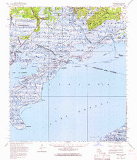
1956 Map of Rigolets
USGS Topo · Published 1966About this map
Pearl River distributaries and the vast coastal wetlands of Fritchie Marsh dominate this mid-century survey of the Louisiana-Mississippi borderlands. The intricate hydrologic network shows the West River, Middle River, and East River carving through Honey Island, a landscape defined by shifting bayous and seasonal lagoons. Human presence is concentrated along the higher ground of the Louisville and Nashville Railroad corridor, where small settlements like Pearlington and English Lookout serve as outposts between the freshwater marshes and the saline waters of Lake Borgne.
Find a feature on this map
95 named features on this map. Tap any name to fly to it.
Don’t see what you’re looking for? This feature index may not catch every label — zoom into the map to look around manually.
Map Details
Editions of this 1956 Rigolets Map
This is the sole edition of this map. No revisions or reprints were ever made.
Other maps of this area

1892 · Chef Menteur
USGS Topo · 1:62,500

1892 · St. Bernard
USGS Topo · 1:62,500

1893 · Rigolets
USGS Topo · 1:62,500

1893 · Shell Beach
USGS Topo · 1:62,500

1893 · Toulme
USGS Topo · 1:62,500

1895 · Bodreau
USGS Topo · 1:62,500

1914 · Nicholson
USGS Topo · 1:62,500

1921 · Nicholson
USGS Topo · 1:62,500

1935 · Slidell
USGS Topo · 1:62,500

1935 · English Lookout
USGS Topo · 1:31,680