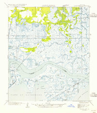
1954 Map of Rigolets
USGS Topo · Published 1954About this map
Ft Pike stands at the strategic nexus where The Rigolets connects Lake Pontchartrain and Lake Borgne. This deep-water pass serves as a primary maritime artery between St Tammany Parish and Orleans Parish, shaped by an intricate network of tidal channels including Salt Bayou and Perdido Bayou. The landscape is dominated by marshlands and ridges like Apple Pie Ridge, while navigation is aided by the W Rigolets LH lighthouse. The Louisville and Nashville RR cuts through the wetlands, paralleling Highway No 90 to bridge the gap between the isolated settlement of Rigolets and the surrounding coastal islands. Notable landforms such as Prevost Island, Hog Island, and Rabbit Island illustrate the fragmented geography of the Louisiana coast during the mid-20th century, before major modern coastal erosion altered these tidewater passes.
Find a feature on this map
54 named features on this map. Tap any name to fly to it.
Don’t see what you’re looking for? This feature index may not catch every label — zoom into the map to look around manually.
Map Details
Editions of this 1954 Rigolets Map
This is the sole edition of this map. No revisions or reprints were ever made.
Other maps of this area

1892 · Chef Menteur
USGS Topo · 1:62,500

1893 · Rigolets
USGS Topo · 1:62,500

1914 · Nicholson
USGS Topo · 1:62,500

1921 · Nicholson
USGS Topo · 1:62,500

1935 · Slidell
USGS Topo · 1:62,500

1935 · English Lookout
USGS Topo · 1:31,680

1936 · North Shore
USGS Topo · 1:31,680

1936 · Chef Menteur
USGS Topo · 1:62,500

1936 · Rigolets
USGS Topo · 1:62,500

1937 · Chef Menteur
USGS Topo · 1:31,680