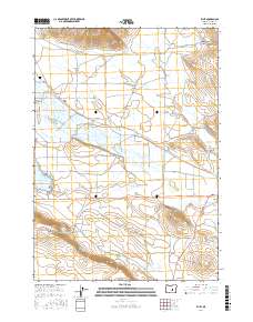
2017 Map of Riley
USGS Topo · Published 2017About this map
Riley stands as a primary point of interest in this high desert landscape, positioned at the junction where Chickahominy Cr meets the local road network. The map reveals a land defined by its water management and sparse ranching infrastructure, most notably the Chickahominy Reservoir and the winding course of Silver Cr. These water sources are vital lifelines in the Oregon interior, dictated by the surrounding topography of Juniper Ridge and the volcanic prominence of Shields Butte.
Find a feature on this map
22 named features on this map. Tap any name to fly to it.
Don’t see what you’re looking for? This feature index may not catch every label — zoom into the map to look around manually.
Map Details
Editions of this 2017 Riley Map
This is the sole edition of this map. No revisions or reprints were ever made.
Other maps of this area

1955 · Burns
USGS Topo · 1:250,000

1958 · Burns
USGS Topo · 1:250,000

1959 · Burns
USGS Topo · 1:250,000

1979 · Moon Reservoir
USGS Topo · 1:24,000

1980 · Capehart Lake
USGS Topo · 1:24,000

1980 · Squaw Butte
USGS Topo · 1:24,000
1981 · Egypt Canyon
USGS Topo · 1:24,000
1981 · Oakerman Lakes
USGS Topo · 1:24,000

1981 · Camp Currey Spring
USGS Topo · 1:24,000
1981 · Suntex
USGS Topo · 1:24,000