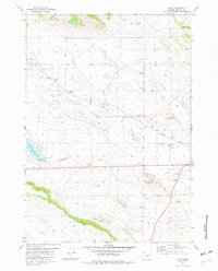
1981 Map of Riley
USGS Topo · Published 1982About this map
Riley sits at the junction of High Desert drainage and ranching life in this early 1980s look at Harney County. The landscape is defined by the broad expanse of Silver Valley and the prominent volcanic rises of Zoglmann Butte and Shields Butte. To the west, the Chickahominy Reservoir provides a vital water source, complete with a Boat Ramp and campground facility, while the intermittent flows of Silver Creek and Chickahominy Creek carve through the sagebrush-covered terrain.
Find a feature on this map
25 named features on this map. Tap any name to fly to it.
Don’t see what you’re looking for? This feature index may not catch every label — zoom into the map to look around manually.
Map Details
Editions of this 1981 Riley Map
This is the sole edition of this map. No revisions or reprints were ever made.
Other maps of this area

1955 · Burns
USGS Topo · 1:250,000

1958 · Burns
USGS Topo · 1:250,000

1959 · Burns
USGS Topo · 1:250,000

1979 · Moon Reservoir
USGS Topo · 1:24,000

1980 · Capehart Lake
USGS Topo · 1:24,000

1980 · Squaw Butte
USGS Topo · 1:24,000
1981 · Egypt Canyon
USGS Topo · 1:24,000
1981 · Oakerman Lakes
USGS Topo · 1:24,000

1981 · Camp Currey Spring
USGS Topo · 1:24,000
1981 · Suntex
USGS Topo · 1:24,000