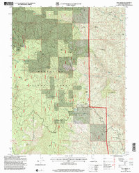
1995 Map of Riley Ridge
USGS Topo · Published 2001About this map
Mendocino National Forest encompasses this high-elevation landscape in Tehama County, where resource extraction and isolated homesteading once defined the local economy. Evidence of the region's mining history is visible in the South Elder Mine and Kleinsorge Mine, while the timber industry is represented by the location of Patton Mill along Mill Creek. This 1990s revision reveals a terrain marked by named clearings and family-identified landmarks such as Steuben Place, Mitchell Place, and Fellow Place, suggesting a legacy of seasonal grazing or early settlement. Connectivity across the ridges is maintained by 4wd tracks and trails crossing prominent features like Riley Ridge, Tatham Ridge, and Whiskey Saddle. Numerous water sources, including Rocky Cabin Spring and Government Spring, provided essential resources for both livestock and the camps that dot the drainage basins of the South Fork Elder Creek and Digger Creek.
Find a feature on this map
48 named features on this map. Tap any name to fly to it.
Don’t see what you’re looking for? This feature index may not catch every label — zoom into the map to look around manually.
Map Details
Editions of this 1995 Riley Ridge Map
This is the sole edition of this map. No revisions or reprints were ever made.
Other maps of this area

1890 · Red Bluff
USGS Topo · 1:250,000

1894 · Red Bluff
USGS Topo · 1:250,000

1949 · Colyear Springs
USGS Topo · 1:62,500

1952 · Paskenta
USGS Topo · 1:62,500

1952 · Anthony Peak
USGS Topo · 1:62,500

1954 · Yolla Bolly
USGS Topo · 1:62,500

1957 · Colyear Springs
USGS Topo · 1:62,500

1957 · Ukiah
USGS Topo · 1:250,000

1958 · Redding
USGS Topo · 1:250,000

1960 · Ukiah
USGS Topo · 1:250,000