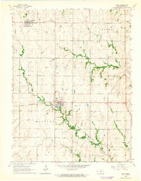
1964 Map of Riley
USGS Topo · Published 1965About this map
Riley and Leonardville serve as the primary agricultural and civic centers in this mid-1960s survey of Riley County. The Chicago Rock Island and Pacific railroad bisects the landscape, providing a vital link for the local economy, while an Old Railroad Grade near Leonardville indicates earlier iterations of the regional transport network. Educational and spiritual life is anchored by the County High Sch and Fairview Ch, with the Athletic Field and Roadside Park offering dedicated community spaces. The terrain is defined by the drainage patterns of Wildcat Creek, Mill Creek, and Little Arkansas Creek, which carve through the townships of Bala, Sherman, and Madison. This map reflects the structured transition of the Kansas prairie into a landscape of organized townships, farms, and small-town infrastructure at the height of the mid-century era.
Find a feature on this map
22 named features on this map. Tap any name to fly to it.
Don’t see what you’re looking for? This feature index may not catch every label — zoom into the map to look around manually.
Map Details
Editions of this 1964 Riley Map
2 editions found
Other maps of this area

1886 · Junction City
USGS Topo · 1:125,000

1889 · Junction City
USGS Topo · 1:125,000

1894 · Junction City
USGS Topo · 1:125,000

1947 · Manhattan
USGS Topo · 1:62,500

1947 · Fort Riley
USGS Topo · 1:62,500

1950 · Keats
USGS Topo · 1:24,000

1951 · Wind Creek
USGS Topo · 1:24,000

1951 · Milford
USGS Topo · 1:24,000

1955 · Fort Riley NE
USGS Topo · 1:24,000

1955 · Milford
USGS Topo · 1:24,000